Standing at the summit of Sveti Jure, Croatia’s second-highest peak at 1,762 meters, you can see from the Adriatic Sea to Bosnia. The view is so expansive that it feels like you’re looking at an entire continent from a single vantage point. Below you, the Croatian coast curls like an invitation, while inland, mountains fold into the distance like layers of a cake. This is why people hike Biokovo Sveti Jure—not just for the accomplishment, but for the moment when you realize how vast and beautiful the world actually is.
The hike to Sveti Jure is one of Croatia’s most rewarding summit experiences, offering increasingly spectacular views with every elevation gain. It’s challenging but achievable for people with decent fitness levels, and the reward—both the summit and the famous Skywalk—makes every sweaty step worth it.
The Biokovo Mountain Range: Context and Drama
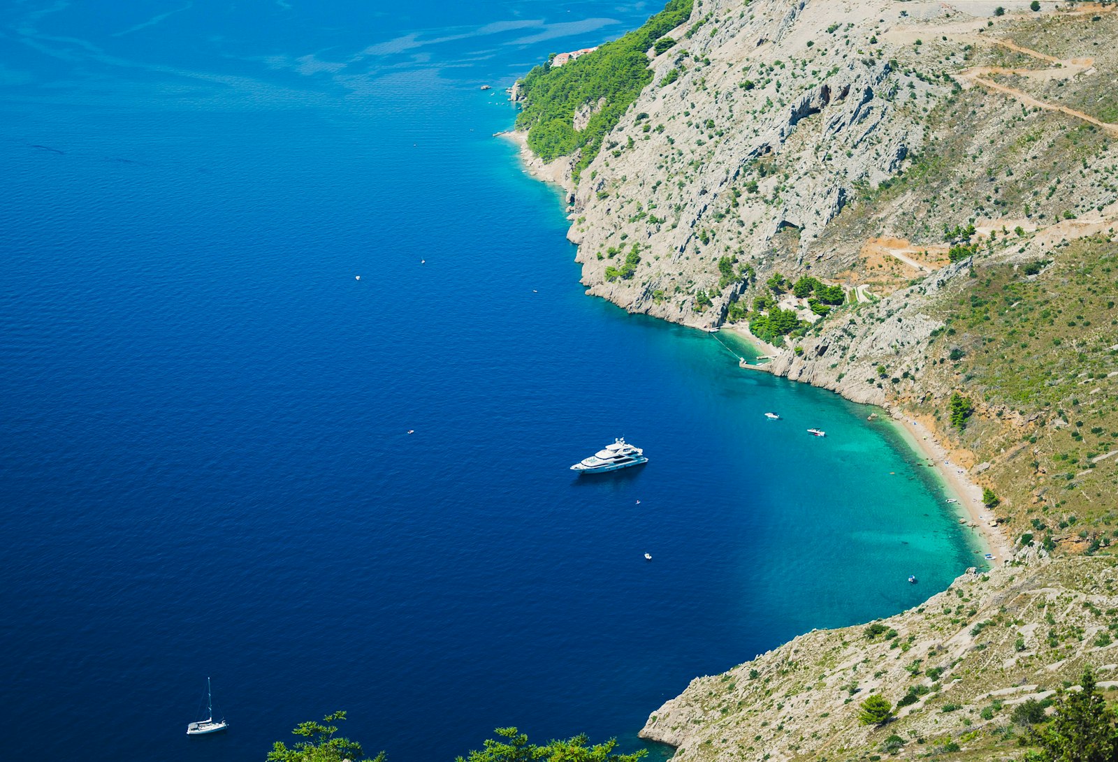
Biokovo isn’t a gentle mountain range. These are serious peaks that rise dramatically from the Dalmatian coast near Makarska. The massif covers about 64 square kilometers and forms a natural barrier between the coast and inland areas. The highest peak is Sveti Jure, and surrounding it are other significant summits, deep valleys, and some of the most dramatic topography in the Mediterranean.
The Biokovo Nature Park protects this area and the incredible ecological diversity found here. The mountains support Mediterranean and Central European plant species, creating a unique botanical zone where cacti and pine forests coexist. Wildlife includes chamois, wild boar, and various bird species that soar on the thermals above the peaks.
The Classic Route: Makarska to Sveti Jure
The most popular and well-marked route starts from Makarska, a coastal town that’s your gateway to the mountains. This hike is approximately 7-8 kilometers one way, with about 1,200 meters of elevation gain. It’s not a casual stroll, but it’s also not mountaineering—most people of average fitness can complete it, though it will challenge you.
The Start: The trailhead is accessible by car from Makarska, though parking near the official start can be tight on busy days. The trail begins through Mediterranean vegetation—low shrubs, rocky ground, and those distinctive white rocks that characterize Dalmatian limestone. Immediately, you’re gaining elevation, and the effort is relentless. There’s no easing into this hike.
The First Hour: The initial section is steep but encourages a steady rhythm. Switchbacks carve up the mountainside, and vegetation gradually changes as you climb. You’ll move from dense scrub into more open rocky terrain. The coast becomes increasingly visible behind you, and motivation comes from knowing the views are only getting better.
Mid-Section: Around the halfway point, the landscape opens up considerably. You’re above the tree line, surrounded by rocky peaks and increasingly expansive views. On clear days, you can see across the Adriatic toward Italy. The psychological boost of these views is real—they give your legs permission to keep moving.
The Final Push: The last section to Sveti Jure involves some scrambling over rocks and more steep terrain. The summit itself isn’t complicated technically, but it’s definitely steep. Many hikers report that the final push feels shorter than it actually is, perhaps because the views become so absorbing that your brain stops counting minutes and starts counting vistas.
Time: Allow 3-4 hours for the ascent, depending on your fitness and pacing. Descent typically takes 2-2.5 hours (easier on the legs than going up, but hard on the knees). Add time for rest, photos, and summit hanging-around time. A full day trip from Makarska should include 6-7 hours of actual hiking time.
Sveti Jure: The Summit Experience
When you reach Sveti Jure’s summit (elevation 1,762 meters), the first thing you notice is that you’ve escaped the intensity of the climb and entered a realm of pure perspective. The mountain’s modest size belies its dramatic position—standing here feels like standing on the edge of something.
On clear days, visibility extends for 60+ kilometers. The Adriatic sprawls below with all its islands, the Dalmatian coast curves along your view, and inland mountains stretch toward Bosnia. On exceptional visibility days, you can supposedly see as far as the Appalachian Mountains in distant Corsica. More realistically, you can see an enormous range of Croatian and regional geography from a single point.
The summit itself is marked with a simple cross (Sveti Jure means “Saint George”), and it’s become a tradition for hikers to add stones to a small cairn at the top. The summit area is surprisingly spacious despite being a peak, and there’s room to rest and absorb the views without feeling crowded, even on busy days.
The wind at the summit can be significant, so bring a windbreaker even if you’re warm during the climb. The temperature is noticeably cooler than Makarska—expect about 10 degrees Celsius difference for every 1,000 meters of elevation.
The Skywalk: The Instagram Moment That’s Actually Worth It
Below the summit, there’s a viewing platform known locally as the Skywalk or Viewing Deck—an overhanging platform that extends from the cliff face and offers an entirely different perspective. This is where the famous photographs come from: hikers dangling their feet over the void, the Adriatic far below, and the impossible blue of the sky and sea in the background.
The Skywalk technically sits on the descent route, so you’ll encounter it on the way down from the summit. It’s completely safe—it’s a properly constructed platform with railings—but the optical illusion of hanging over a massive drop is thrilling. This is the Instagram-famous view, and honestly, the hype is justified. It’s genuinely one of Europe’s most dramatic photo locations, not because of construction or engineering, but because of the genuine topography beneath it.
The platform can get crowded during peak hiking hours, with people waiting turns for photos. If you want the platform to yourself (or mostly to yourself), consider starting your hike very early—sunrise starts mean summit arrival by mid-morning when most day hikers are just beginning their climb.
Difficulty and Who Should Go
Fitness Level: This hike is rated as moderate to moderately strenuous. You need reasonable cardio fitness and some experience hiking. Complete hiking beginners could do it, but it would be quite challenging. People with reasonable fitness levels (you can comfortably walk for 2-3 hours without stopping) should be fine.
Technical Difficulty: This is not a rock-climbing hike. There’s no ropes, no exposed scrambling, no special equipment needed. Your ankles need to handle rocky terrain, and you need to be comfortable with steep slopes, but it’s a hiking trail, not mountaineering.
Knees and Joints: The descent is harder on knees than the ascent. People with knee problems should consider this carefully or use trekking poles (highly recommended for descent regardless).
Altitude: At 1,762 meters, you’re not going to hit altitude sickness issues that affect higher mountains. If you can breathe at sea level, you can breathe here—you’ll just notice the thinner air slightly, especially during exertion.
What to Bring and How to Prepare
Essential Gear:
- Plenty of water (at least 2 liters, more in summer)
- Snacks with calories (trail mix, energy bars, fruit)
- Good hiking boots with ankle support
- Sun protection (sunscreen, hat, sunglasses)
- Wind/rain jacket (weather can change)
- Trekking poles (highly recommended for knees on descent)
- Map or GPS app with offline capability
Optional but Recommended:
Pre-Hike Preparation:
Do some cardio training before attempting this hike, especially if you’re not regularly exercising. A few weeks of hill walking or stair climbing will make an enormous difference in your experience. The hike is achievable without extensive training, but you’ll suffer less with some preparation.
Seasonal Considerations
Summer (June-August): Popular season, but very hot. Start early (before 7 AM ideally), bring extra water, and be prepared for sun exposure. Afternoon thunderstorms can develop, so watch the weather.
Spring (April-May): Pleasant temperatures, lower crowds, and the mountain is turning green. This is genuinely a great time to hike here.
Fall (September-October): Similar to spring—comfortable temperatures, good visibility, and manageable crowds. Many locals consider this the best season.
Winter (November-March): Snow is possible above 1,500 meters, which adds difficulty and danger. Not recommended unless you have winter hiking experience and proper gear.
The Biokovo Nature Park: Context and Responsibility
You’re hiking through a protected nature area, so leave no trace. The plants here are hardy but delicate in their own way. Stay on marked trails, don’t pick flowers, and don’t create new paths. The Biokovo Nature Park is managed to preserve the ecological and geological integrity of the range, so help them out by being a responsible visitor.
Wildlife is present but not typically seen by day hikers. You might spot birds of prey, especially if you’re quiet and observant. Respect the animals’ habitat by maintaining distance and keeping noise levels reasonable.
Practical Details
Getting There: Makarska is accessible by car or bus from major Dalmatian cities like Split and Dubrovnik. The drive from Split is about 1.5 hours. Several car rental companies operate in Split if you need transportation.
Where to Start: Ask locals or your accommodation for directions to the mountain entrance/parking area. Signage is decent but can be weather-worn. The town of Makarska itself is a pleasant beach town if you want to spend time there before or after your hike.
Guides: You can absolutely hike this solo on the marked trail. However, guided hikes are available through several outfitters in Makarska and nearby towns. Guides are helpful if you’re unsure about navigation or want to learn more about the ecology and geology.
Best Time to Start: Early morning is preferable to avoid afternoon crowds at the summit and Skywalk, plus you’ll have better light for photography throughout the day.
Why Biokovo Sveti Jure Matters
This hike matters because it connects you directly to Dalmatian geography. Instead of observing the coastline from sea level, you’re above it, seeing how mountains meet sea and understanding the topography that shaped regional history. You’re hiking through a genuine wilderness within a populated region, and the experience feels earned.
The summit rewards effort with perspective. The Skywalk delivers thrills. The views encompass an entire world. And when you descend back toward Makarska, dusty and tired and satisfied, you understand exactly why Croatian hikers keep coming back to Biokovo.
This is mountaineering made accessible, and it’s absolutely worth your time.

Leave a Reply