“God created the world, but the Dutch created the Netherlands”
This Dutch saying captures something essential about national identity: the Netherlands is not just inhabited; it is built. Deliberately, patiently, ingeniously built. Standing in the Flevoland polder—an entire province of 970 square miles that didn’t exist before 1942—you’re standing on humanity’s most ambitious act of landscape engineering. Walk the Afsluitdijk, a wall of earth 20 miles long holding back the sea. Visit the windmills at Kinderdijk, where rows of white-cloaked giants stand like sentries over the water they once pumped out by hand. These aren’t just tourist attractions; they’re evidence of an obsession that shaped Dutch character and created the country itself.
Roughly a quarter of the Netherlands today is below sea level. In medieval times, much of what is now the Netherlands was water—marshes, lakes, river deltas, and the aggressive Zuiderzee (Southern Sea). The low countries were literally on the edge of survival, threatened every winter by storms and tidal surges. Surviving here required not just settlement but constant, organized, intelligent defiance of water. This struggle created a distinct people: the Dutch. To understand them, you must understand their relationship with water.
The Medieval Foundations
The practice of protecting land from water through dikes is ancient—the Romans built them. But the Dutch developed it into something more sophisticated. Beginning in the 10th and 11th centuries, peasants in what is now Holland began building dikes and reservoirs to manage the recurring floods. These weren’t defenses against the sea so much as management systems for the water that fell as rain, rivers brought from upstream, and the tides that pushed water inland.
The key innovation was the polder system. A polder is a low-lying tract of land enclosed by dikes, with water managed internally by a network of canals and channels. Water flowing into the polder during storms or high tides could be trapped and managed. In dry seasons, water would drain out. The polder was a system, not just a barrier—a mechanical solution to the problem of living below sea level.
But moving water requires power, and for centuries, that meant mills. The windmill was adapted to Dutch needs around the 1400s. Unlike traditional windmills used to grind grain, these water mills could pump water from low-lying polders up and over the dikes, spilling it into higher canals or rivers. The technical term was “scoop wheels”—buckets mounted on a wheel that would lift water with each rotation.
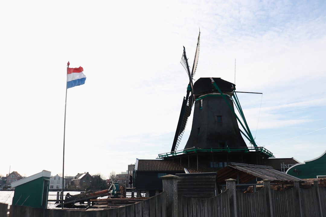
If you visit Kinderdijk, near Rotterdam, you’ll see 19 of these mills still standing, a UNESCO World Site that is perhaps the most concentrated collection of functional historic windmills anywhere on Earth. From the visitor platform, you can see them stretching into the distance, white walls and dark wooden cap roofs, with broad sails spread against the sky. Imagine this scene in 1740, when all 19 were operating simultaneously during high-water conditions—a coordinated mechanical dance performed by each mill’s miller, working together to push water out faster than it came in. The sound would have been extraordinary, the work relentless, but the effect was survival.
What’s remarkable about Kinderdijk isn’t just the engineering but the organization. The mills weren’t operated by some central authority. The local waterschappen (water boards) owned and operated them. These were among the first genuinely democratic institutions in Europe—organizations run by the property owners whose land depended on the water management. Decisions were made collectively. Mills were maintained through shared labor and shared expense. The Netherlands developed sophisticated systems of law and custom to govern water management, which in turn became the basis for broader democratic principles.
The Landscape Made Real: Flevoland
To see land reclamation on a scale that still strains comprehension, you must visit Flevoland. This entire province—comprising two polders, the Wieringermeer (drained 1612), the Haarlemmermeer (drained 1852), and the East and South Flevoland polders (drained in the 20th century)—is entirely human-made. When the Dutch completed the Afsluitdijk in 1932 (the 20-mile dam that sealed off the Zuiderzee from the North Sea), they were able to transform the enclosed water into the Ijsselmeer, a freshwater lake. And then they got to work.
East Flevoland, the first of the Zuiderzee Works polders to be drained, took only four years to empty—from 1957 to 1961. Engineers pumped roughly 900 million tons of water out of a lake and overland into the surrounding sea. When the water receded, they were left with a blank canvas: perfectly flat, entirely bare earth. What do you do with such a space? The Dutch planned it as completely and carefully as they might plan a ship or a city. Roads were laid in a grid. Farms were established with careful attention to soil quality and drainage. Communities were built from scratch. The towns of Lelystad and Almere rose from nothing, not as haphazard settlements but as planned centers.
Today, if you drive into Flevoland, you’ll notice its strangeness immediately. The landscape is entirely flat—there’s not a hill within 50 miles. The villages are laid out in orderly grids. The character feels different from the rest of the Netherlands, because it was designed rather than grown. Trees, planted generations ago, have now matured, and the polder has begun to look less alien. But the underlying reality persists: this is humanity imposing order on nature with absolute conviction.
The Ijssel Museum in Kampen and the Batavia shipyard in Lelystad help tell this story. But the best way to understand it is simply to drive through Flevoland and feel the eerie smoothness of the landscape. This is what victory over water looks like: a province designed and built with the precision of a machine.
The Deltaworks: Defending Against Catastrophe
If polders are the story of Dutch expansion, then the Deltaworks are the story of survival in the face of catastrophe. The great storm of 1421 killed tens of thousands and flooded 90 villages in Holland and Zealand. The disaster of 1953, when a storm surge broke dikes in the southwest and killed nearly 2,000 people, was one of Western Europe’s deadliest peacetime disasters in the 20th century. These events shaped national consciousness.
The Deltaworks—a system of dikes, dams, and sluices built after 1953 to prevent future catastrophes—remains one of the world’s most impressive examples of defensive engineering. The project, which continued for decades, included the construction of the Oosterscheldekering (Eastern Scheldt Storm Surge Barrier), a barrier nearly a mile long with 62 gates that can close during storms but normally remains open, allowing tidal flow to continue.
You can drive across some of these structures. The Afsluitdijk, completed in 1932, stretches straight across the Ijsselmeer like a highway. Stop at one of the rest areas and get out; you’ll stand 25 feet above sea level, looking out at water on both sides. The barrier doesn’t just hold water; it connects North Holland to Friesland and has fundamentally altered traffic patterns and development in the northern Netherlands.
The Deltapark Neeltje Jans, near Zeeland, is an excellent museum dedicated to the Deltaworks. Inside, you’ll find exhibits explaining the engineering challenges, the human stories, and the ongoing maintenance required. There’s also an open-air park where you can see scale models of the barriers and learn about climate change and future flood management. It’s a sobering but fascinating place, reminding visitors that for the Dutch, water management isn’t an historical curiosity; it’s an ongoing necessity.
The Windmills: Mechanical Marvels
The windmills at Kinderdijk, Schermerhorn, and elsewhere across the Netherlands are more than charming relics. They’re mechanical computers—devices that solved an energy problem with elegance and consistency. Before steam power, these mills were the most sophisticated machines most people would ever see. They required constant maintenance, careful operation, and skilled craftsmen who understood their mechanics.
Standing inside a working windmill (many are open to visitors), you can see the massive wooden gears transferring the rotation of the sails to the scoop wheel. The energy conversion is visible and almost beautiful in its directness. Wind, captured by four broad sails of cloth, powers a wooden shaft, which turns gears, which operate a wheel that lifts water. The mathematical relationships are pure mechanics—proportions and angles that had been refined over centuries.
The miller’s job was part engineer, part weather forecaster, part diplomat. A miller needed to understand how to trim the sails for different wind conditions, how to adjust the gears, how to maintain the machinery, and how to coordinate with other millers to ensure that water management was handled efficiently across an entire region. Millers formed guilds and developed specializations. Some were known for their skill with particular types of mills or particular difficult water-management problems.
Many of the 19 windmills at Kinderdijk date to the 18th century. The oldest, the Nederwaard mill, was built in 1468. Walking among them, you’ll notice that each is slightly different. Some have wooden caps that rotate to face the wind; others have fixed tops with internal mechanisms. Some have brick bases with thatched roofs; others are entirely stone. The variation reflects different periods of construction and different solutions to similar problems.
The Amsterdam Canal Ring and Water Management
Even the famous Grachtengordel of Amsterdam is fundamentally a water-management system, though it’s become beautiful in the process. The three main canals of Amsterdam—the Herengracht, Keizersgracht, and Prinsengracht—were dug in the early 1600s to expand the city and manage its water. The surrounding moat, the Singel, was originally just a defensive ring, but it also served drainage purposes. Every canal in Amsterdam is a managed water channel, designed to move water away from buildings and out of the city.
The houses lining these canals sit precisely at the right elevation—not so high as to be isolated, not so low as to be flooded. The basement levels of the buildings are actually at or below the water table; they were used for storage but also served as part of the water-management system. Water would percolate in, be managed, and be pumped out. It’s all connected.
Modern Challenges: Keeping Back the North Sea
Today, Dutch water management faces new challenges. Rising sea levels due to climate change make the old defenses potentially insufficient. The Dutch aren’t retreating; they’re adapting. Rather than simply building higher dikes, modern thinking emphasizes working with water rather than simply against it. New developments include “water squares”—urban spaces that can temporarily hold floodwater. Some low-lying areas are being deliberately flooded during high-water events rather than protected. Rice paddies are being reintroduced to allow water retention. The relationship with water is evolving, but the underlying principle remains: the Dutch solve water problems through engineering, organization, and persistent innovation.
The National Character
This history of water and land reclamation did something to the Dutch character that persists today. It created a people comfortable with collective action toward practical goals. It created engineers and problem-solvers. It created a culture of incremental, methodical improvement. It created a certain kind of confidence—the confidence of people who have stared down the North Sea and won.
When you drive through the Netherlands today—across the flat landscape, through the geometrically perfect polder grids, over the great dikes and dams—you’re driving through the physical expression of a centuries-long argument between human will and natural force. The Dutch won. Or rather, they’re still winning, one polder, one dike, one carefully managed water channel at a time. That’s not bragging; it’s what the landscape tells you about the people who built it.

Leave a Reply