On November 9, 1989, the Berlin Wall fell in a torrent of euphoria, champagne, and sledgehammers. Thirty-five years later, the 160-kilometer Berliner Mauerweg — the Berlin Wall Trail — traces the entire perimeter of what was once West Berlin, threading through neighborhoods that have been transformed beyond recognition and others that still bear the unmistakable scars of division. Walking this trail is one of the most powerful historical experiences available in modern Europe.
The Trail Itself
The Berliner Mauerweg was officially established in 2006, following the route where the Wall once stood or running parallel to it along former patrol roads used by East German border guards. The trail is divided into 14 stages, each between 7 and 21 kilometers, and is well-marked with signposts bearing the Wall Trail logo. Most of the path is paved and flat, making it accessible to cyclists and walkers alike. Information panels at regular intervals provide historical context, photographs from the Cold War era, and personal accounts from those who lived on either side.
East Side Gallery: Art on the Remains
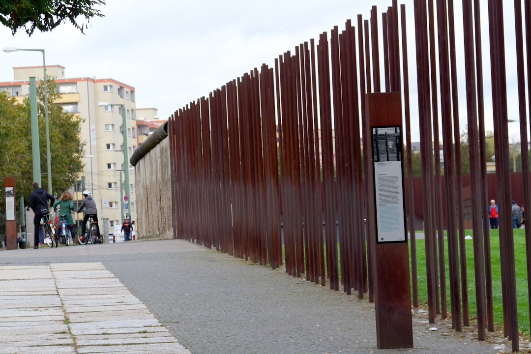
The East Side Gallery is the longest surviving stretch of the Wall, extending 1.3 kilometers along Mühlenstrasse near the Oberbaum Bridge. After reunification, artists from around the world were invited to paint its eastern face — the side that had been inaccessible to West Berliners and forbidden to East Berliners. Dmitri Vrubel’s “My God, Help Me to Survive This Deadly Love,” depicting Brezhnev and Honecker in a fraternal kiss, has become one of the most reproduced images of Cold War art. Birgit Kinder’s Trabant crashing through the Wall is another iconic piece. The gallery was controversially restored in 2009, and some original murals were lost, but it remains an essential stop.
Checkpoint Charlie: Tourist Trap with a Purpose
Yes, Checkpoint Charlie is touristy. The actors in Allied uniforms posing for photos can feel crass. But the location matters. This was the crossing point for Allied personnel and foreigners between the American and Soviet sectors, and it was here in October 1961 that American and Soviet tanks faced each other in a standoff that could have triggered World War III. The nearby Mauermuseum — Haus am Checkpoint Charlie, founded in 1962 while the Wall still stood — documents escape attempts with an obsessiveness that borders on the overwhelming: hot air balloons, tunnels, modified cars with hidden compartments, even a one-man submarine.
Bernauer Strasse: The Heart of Memory
If you visit only one Wall-related site in Berlin, make it the Berlin Wall Memorial on Bernauer Strasse. This is where the division was most dramatically visible — the street itself was the border, with apartment buildings on the eastern side whose front doors opened into the West. In the early days after August 13, 1961, residents jumped from upper-story windows to reach freedom while authorities bricked up the lower floors. The memorial preserves an original section of the Wall with its death strip, watchtower foundations, and the Chapel of Reconciliation, built on the site of a church that the East German government dynamited in 1985 to improve sight lines for border guards.
Ghost Stations and Hidden Traces
Among the Wall Trail’s most evocative features are the so-called ghost stations — Geisterbahnhöfe — subway stops in East Berlin that West Berlin trains passed through without stopping. Platforms were sealed, patrolled by armed guards, and lit by dim emergency lighting. Today, Nordbahnhof station has a permanent exhibition about these spectral transit points. Meanwhile, throughout Berlin, a double line of cobblestones set into streets and sidewalks marks the exact path of the Wall. It is startling how often you cross this line without realizing it, a reminder of how thoroughly the city has healed over its wound.
Mauerpark and Living Memory
Mauerpark — literally “Wall Park” — sits in the former death strip between Prenzlauer Berg and Wedding. On Sundays, it hosts a famous flea market and an open-air karaoke session that draws hundreds of spectators. The park’s transformation from no-man’s-land to one of Berlin’s most vibrant public spaces encapsulates the city’s approach to its own history: remember, but also live. Fragments of the Wall here serve as graffiti canvases, constantly evolving. The trail continues through Invalidenfriedhof cemetery, past the spot where Günter Litfin became the first person shot trying to cross the border on August 24, 1961, and along the Spree River where the Wall ran through the water itself.
Walking the full trail takes most people four to five days. You do not need to complete it all at once, and sections can easily be reached by S-Bahn and U-Bahn. But there is something meaningful about following the entire route — about understanding viscerally that this wall was not a short barrier across a single street, but a 160-kilometer cage around half a city, cutting through forests, rivers, and neighborhoods. The Berlin Wall Trail is not just a walk through history. It is history made legible by footsteps.
Leave a Reply